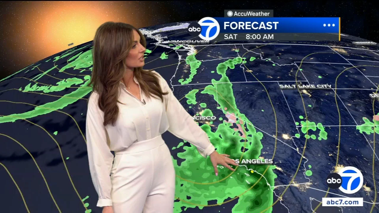
After a warm and sunny Easter Sunday, Southern California is set for a significant weather shift. Temperatures will drop, and rain chances are increasing by late Friday, potentially bringing snow to higher elevations.
Southern Californians are enjoying a respite of warm, sunny weather this Easter Sunday, an idyllic start to the week for many families gathered for holiday celebrations. However, this pleasant stretch is poised for a significant meteorological shift as a notable cooldown begins to settle over the region, bringing with it increasing chances of rain by the end of the week. Forecasters are tracking a system that will usher in lower temperatures across coastal areas, valleys, and even the deserts, with the potential for showers stretching from late Friday into the weekend, and even a possibility of light snow in the highest mountain elevations. This transition from spring warmth to cooler, wetter conditions marks a typical, albeit sometimes abrupt, change in Southern California's often unpredictable April weather patterns, signaling that residents should prepare for a sudden departure from the current favorable conditions.
Southern California’s weather, particularly in spring, is known for its dramatic and often rapid fluctuations. The region, characterized by its Mediterranean climate, typically experiences warm, dry summers and mild, wet winters. However, the shoulder seasons of spring and autumn can act as a battleground between lingering winter chill and encroaching summer heat, leading to forecast volatility. This week's impending cooldown and rain chances are not entirely uncharacteristic for April, which historically sees some of the last significant precipitation events before the long, dry summer months. The region often experiences "April showers" as the jet stream occasionally dips southward, bringing moisture from the Pacific. These late-season systems are crucial for local water supplies, particularly in mountain communities where snowmelt contributes significantly to reservoirs. The current forecast, indicating a shift from clear, warm conditions to cooler temperatures and rain, aligns with this historical tendency for dynamic spring weather, reminding residents that even after periods of sunshine, a return to winter-like conditions can always be just around the corner, as detailed by ABC7 Los Angeles.
The current forecast indicates a clear and decisive shift in Southern California's weather pattern over the coming week, following the pleasant Easter Sunday. According to an ABC7 Los Angeles report, a cooldown is already underway, with temperatures beginning to drop in some areas as early as Tuesday. Coastal regions, such as those along the immediate Los Angeles and Orange County lines, are expected to experience low clouds and fog, a stark contrast to the current clear skies. On Tuesday, these areas anticipate a high of 77 degrees and a low of 54 degrees, with similar conditions extending into Wednesday. However, the more significant cooling trend is projected to arrive later in the week, specifically on Friday. Rain chances are expected to escalate significantly by late Friday night and continue through Saturday, with showers potentially lingering into Sunday.
The impact of this weather system will be broad, affecting various microclimates within Southern California. For the valleys and Inland Empire, Tuesday will see highs around 80 degrees and lows of 48, with these mild conditions persisting for a few days before the rain moves in on Friday night. Mountain communities, such as those in the San Gabriel or San Bernardino ranges, are bracing for clear skies with a high of 67 and a low of 35 on Tuesday, but the forecast shifts dramatically by the weekend. Rain is not anticipated until Saturday, and there's a distinct possibility of light snow at higher elevations early Sunday morning, signaling a more significant dip in temperatures. Desert areas, including Palm Springs which is expected to reach 95 degrees on Tuesday, will also experience this cooling trend. The High Desert is slated for some rain this weekend, though the exact precipitation amounts for the Low Desert remain uncertain. This comprehensive pattern change is a primary point of focus for local weather agencies, as residents prepare for significantly different conditions than those experienced during the holiday weekend, a common theme for Southern California which often experiences abrupt weather shifts, as observed in recent trending topics around preparedness and economic impacts, for instance, related to oil prices which can affect transportation and supply chains, as highlighted in a CNN report on general trending topics, though not directly linked to this specific weather event, underscores the broader interconnectedness of issues.
While the immediate focus is on the regional weather, broader economic factors, such as rising crude oil prices discussed by WKTV, could indirectly influence long-term weather-related preparedness and recovery efforts, should any severe impacts arise from the coming storms. The rising cost of fuel affects transportation logistics, which in turn could impact the availability and cost of resources needed for emergency responses, underscoring the complex interplay between seemingly disparate global and local issues. However, for now, the primary concern for Southern Californians is the imminent shift from pleasant Easter weather to a cooler, wetter, and potentially snowy, late-week environment, a transition that warrants careful planning for outdoor activities and travel, particularly as details regarding the exact timing and intensity of the rain and snow develop.
This impending weather shift in Southern California carries several significant implications for residents and regional planning. Firstly, the transition from warm, sunny Easter conditions to cool, rainy, and potentially snowy weather by the weekend highlights the variability inherent in the region's climate. While pleasant weather often characterizes late March and early April, these late-season systems are vital for recharging local water supplies. The snowfall predicted for higher elevations, even if light, will contribute to the snowpack, which is a critical source of water for the region as it melts throughout the warmer months. This underscores the delicate balance of Southern California's water infrastructure and the importance of every precipitation event.
Secondly, the rapid change could pose challenges for travel and outdoor activities. Travelers returning from Easter weekend excursions should be prepared for wet roads and potentially reduced visibility, particularly on Friday night and Saturday. Mountain travel, in particular, could be impacted by snow, requiring chains or specialized vehicles. This annual phenomenon often catches some unaware, leading to increased traffic incidents. Furthermore, for outdoor agriculture or construction, the sudden drop in temperature and moisture could delay operations, though for most urban dwellers, it mainly means a shift indoors. This weather pattern, although not extreme, serves as a natural reminder of the need for preparedness and adaptability in a region constantly balancing climatic extremes.
Lastly, from a broader climate perspective, these late-season rain and snow events are becoming increasingly critical in an era of climate change, characterized by warmer temperatures and more frequent droughts in the Western United States. While one cold, wet weekend does not reverse long-term trends, the contribution to the snowpack and local reservoirs is more valuable than ever. Monitoring these systems offers insights into the resilience of our natural environment and the necessity of robust water conservation strategies. The public's awareness of these shifts, often spurred by local news coverage, can also foster a greater appreciation for weather patterns and their profound impact on daily life and long-term sustainability goals in Southern California.
Digging deeper into the specifics, the cooling trend is not expected to be a drastic, single-day event but rather a gradual decline in temperatures leading up to the main precipitation period. ABC7 Los Angeles’ forecast indicates that even on Tuesday, while coastal areas will see foggy mornings, afternoon highs in places like Los Angeles and Orange County will still reach a mild 77 degrees, remaining largely sunny. This implies that the initial stages of the cooldown will be subtle, with the most noticeable changes related to marine layer presence rather than a sharp temperature plunge. The National Weather Service's observation of low clouds and fog along the coast reinforces this initial atmospheric shift, hinting at increasing moisture levels even before the main storm system arrives.
The timing of the precipitation is a crucial detail for planning. The forecast explicitly points to rain arriving "late Friday night into Saturday," with showers anticipated to "linger on Sunday." This implies a weekend-long wet period, which could impact weekend plans for many Southern Californians. Given that Easter Sunday is past, the primary affected weekend would be the one following. While the article's headline references a warm and sunny Easter, the main body of the forecast details the weather for the upcoming week from Tuesday onward, leading into the subsequent weekend. For mountain communities, the mention of "a little snow at higher elevations early Sunday" is a key piece of information, suggesting that residents planning to visit higher altitudes should monitor conditions closely for potential road closures or advisories, as well as prepare for colder, potentially hazardous, driving conditions. This type of weather event, common in spring, typically sees a mix of rain at lower elevations while delivering snow to peaks above 5,000-6,000 feet, which can significantly enhance the snowpack, contributing to water resources.
Furthermore, the varied impact across the region's diverse geography is noteworthy. The deserts, for instance, often experience vastly different conditions than the coast or mountains. While Palm Springs expects a high of 95 on Tuesday, indicating persistent heat in the low desert, the High Desert is specifically mentioned as receiving "some rain this weekend." The uncertainty surrounding precipitation amounts in the Low Desert highlights the localized nature of these systems and the challenges in precise forecasting for all regions. This complexity often necessitates residents in different areas to consult specific local forecasts, potentially using tools like the free Accuweather app mentioned in the ABC7 Los Angeles report, to get the most accurate and up-to-date information for their specific microclimate. Such detailed regional variations ensure that the weather story for Southern California is rarely monolithic but rather a mosaic of interconnected but distinct meteorological events.
As Southern California transitions from pleasant Easter weather to a cooler, wetter pattern, the coming days will be critical for observing the specifics of this weather system. Residents should closely monitor forecasts, particularly on Friday and throughout the weekend, for updates on rainfall totals and potential impacts. The National Weather Service and local news outlets like ABC7 Los Angeles will provide ongoing updates, including any watches or warnings, which can be accessed via their respective platforms. Travelers, especially those heading to mountain areas, should prepare for winter driving conditions if snow materializes. Beyond the immediate forecast, this event underscores the importance of resilient infrastructure in a region prone to both drought and occasional heavy precipitation. It also serves as a timely reminder for ongoing water conservation efforts, even during periods of rain, as securing water resources remains a long-term challenge for Southern California.
A complex weather pattern across the US promises milder temperatures for many, but also introduces widespread shower chances and continued fire danger in some regions.

Patrick Mahomes is undergoing an intense 7-hour daily rehab regimen, signaling deep commitment to sustaining the Chiefs' dynasty, while Brittany Mahomes drives strategic development for the Kansas City Current, showcasing a powerful dual influence on Kansas City sports.
Madison is set for a significant warming trend this week, with temperatures rising from the low 30s to near 60 degrees, bringing multiple chances of rain, particularly towards the end of the week.