Madison Gears Up for Warming Trend and Rain Chances After Chilly Start
Madison is set for a significant warming trend this week, with temperatures rising from the low 30s to near 60 degrees, bringing multiple chances of rain, particularly towards the end of the week.
Madison, Wisconsin, is poised for a notable shift in weather patterns this week, transitioning from unseasonably cold temperatures today to a significant warming trend that will see highs approach 60 degrees by Friday. This welcome change will also usher in multiple opportunities for precipitation, with the most widespread showers expected towards the latter half of the week. After a snowy Saturday, Sunday brought clear skies but continued below-average temperatures, setting the stage for a dramatic turnaround in conditions over the coming days, according to WMTV 15 NEWS. Residents can anticipate a gradual climb in temperatures, moving well above seasonal averages, alongside increasing chances of rain that could include early week freezing drizzle before fully transitioning to milder, wet conditions.
Background and Context of Spring Transition Weather
The fluctuating weather patterns currently observed in Madison are characteristic of early spring in the Upper Midwest, a region notorious for its volatile transitions between seasons. Historically, March often serves as a battleground between lingering winter chill and the encroaching warmth of spring. It's not uncommon for areas like Madison to experience significant temperature swings within a single week, as cold air masses from the north clash with warmer, moisture-laden air pushing up from the south. High-pressure systems, such as the one noted moving from the northern Great Lakes into the lower Great Lakes today and tonight, typically bring clear, dry, but often colder conditions as they settle over a region. However, as these systems shift, they pave the way for changes in air currents, allowing warmer southerly flow to dominate, leading to rapid temperature increases. This dynamic interplay of atmospheric pressures and air masses is a well-understood phenomenon that meteorologists closely monitor to predict the often-unpredictable nature of early spring weather. The transition from cold, dry conditions to warmer, wetter weather, possibly with thunderstorms, reflects the typical northward progression of the jet stream and the increased availability of moisture as temperatures rise, signaling the gradual but inevitable retreat of winter's grip.
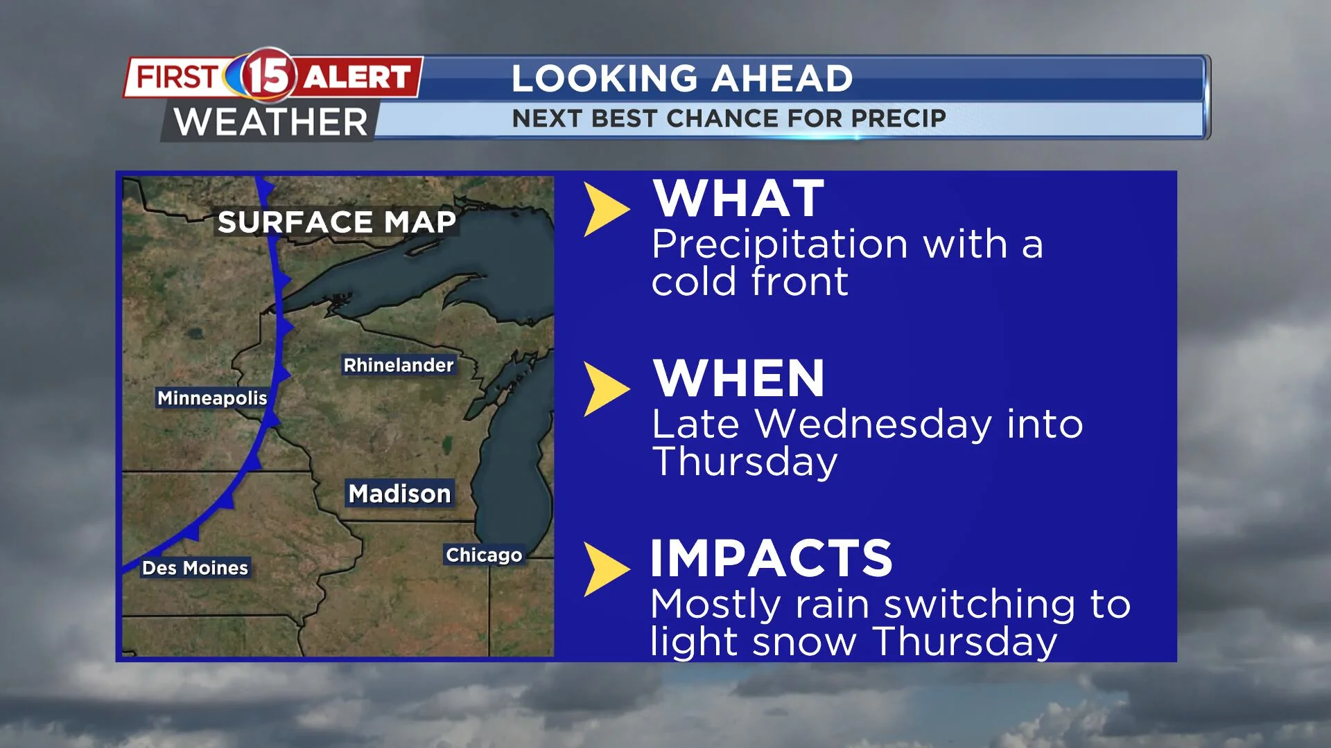
Key Developments: From Cold Snap to Warming Trend and Rain
Madison started the week under the influence of a high-pressure system, which, despite bringing plenty of sunshine, kept temperatures firmly below average. Highs struggled to reach the low 30s on Sunday, following a snowy Saturday. The dry, clear conditions overnight into Monday also allowed for another chilly start, with temperatures dipping into the teens, as reported by WMTV 15 NEWS. However, this cold snap is short-lived. A significant warming trend is on the horizon, with temperatures expected to trend above average consistently throughout the work week. Monday will see temperatures begin to rise above normal as southerly flow strengthens, maintaining dry conditions through the day. The first signs of precipitation are anticipated late Monday night into Tuesday, bringing light rain, though there's a possibility of freezing drizzle or a few flurries mixing in during the initial phase before temperatures fully warm. Forecast uncertainty increases from Tuesday night into Wednesday, with models disagreeing on the exact track of a system potentially moving from eastern Kansas into lower Michigan. This divergence affects the precise rain chances for the region during this period. Regardless of the exact track, the overarching trend points towards increasing moisture and milder conditions. The best potential for widespread showers is forecast for Thursday into Friday as another disturbance moves through the area. Late in the week, developing low pressure over the Great Plains is expected to track west and north of the region, significantly increasing the likelihood of rain from Friday into Friday night. Temperatures are projected to be near 60 degrees during this period, with the possibility of a few rumbles of thunder, indicating the presence of more unstable air. Rain is then expected to taper off early on Saturday, leaving dry conditions and continued mild temperatures for the upcoming weekend. This period of change marks a definitive shift away from the colder, drier conditions of the past few days towards a more spring-like environment.
Analysis: What This Means for Madison Residents
This upcoming weather shift holds significant implications for Madison residents, impacting everything from daily commutes to weekend plans and even the local economy. The rapid swing from below-average temperatures to nearly 60 degrees within a week is substantial and highlights the variability of early spring. For commuters, the initial chances of freezing drizzle or flurries on Monday night into Tuesday necessitate caution on the roads, as even light frozen precipitation can create hazardous conditions. However, the subsequent warming trend means less concern about ice and more about navigating wet roads. For those planning outdoor activities, the latter half of the week, especially Thursday and Friday, will require umbrellas and rain gear, contrasting sharply with the clear skies of early week. The potential for thunder on Friday, coupled with temperatures nearing 60, not only signals the arrival of warmer air but also injects more energy into the atmosphere, potentially leading to more robust weather systems. From an economic perspective, milder temperatures can spur outdoor recreation and retail, while sustained rain could impact agricultural activities or construction projects if it becomes excessive. Furthermore, the variability in model forecasts for Tuesday night into Wednesday serves as a crucial reminder of the inherent challenges in predicting precise storm tracks and precipitation amounts, especially during transitional seasons. This uncertainty means residents should remain flexible with plans and stay updated with the latest forecasts, perhaps through reliable sources like the WMTV15 First Alert weather app, to account for potential adjustments in the forecast as the week progresses. This period of meteorological transition is a classic example of why continuous monitoring of local weather updates is essential for residents to effectively plan and prepare.
Additional Details on Precipitation and Temperature Ascent
The detailed forecast provided by WMTV 15 NEWS outlines a nuanced progression of both temperature and precipitation throughout the week. Following the current cold snap, marked by low 30s highs today and teens overnight, the warming trend begins in earnest on Monday. Southerly flow will be the primary driver, pushing temperatures above seasonal averages, setting the stage for a week of increasingly mild conditions. The initial precipitation, expected late Monday night into Tuesday, is notable for its potential to include light rain, freezing drizzle, or a few flurries. This mixed precipitation is characteristic of early spring transitions when the ground and lower atmosphere can still be cold enough to support wintry precipitation even as warmer air moves in aloft. As the week progresses, the chances for rain become more pronounced and widespread. Thursday and Friday are highlighted as having the best potential for significant showers. This period coincides with the tracking of developing low pressure from the Great Plains, which is projected to move west and north of the Madison region. This particular track is favorable for bringing ample moisture into the area. The forecast of temperatures near 60 degrees by Friday, coupled with the possibility of thunder, indicates a robust warm air mass and sufficient atmospheric instability to support convective activity. While the early week might see some uncertainty regarding the exact path and impact of a system tracking from eastern Kansas into lower Michigan, the overall trend towards warmer and wetter conditions remains consistent across forecast models for the latter half of the week. This comprehensive look at the week's weather underscores a significant meteorological transition, from winter's lingering chill to the more dynamic and often wetter conditions associated with spring.
Looking Ahead: Mild Weekend and Continued Monitoring
As the week draws to a close, Madison is expected to settle into a period of continued mild temperatures, with rain tapering off early on Saturday, leading to dry conditions for the remainder of the weekend. This outlook provides a pleasant contrast to the cold start of the week and offers a glimpse into typical spring weather. While the immediate forecast looks favorable for a mild weekend, residents should remain vigilant regarding future weather developments. Early spring is notorious for its volatility, and further shifts, including potential cold snaps or periods of heavy rain, cannot be entirely ruled out in the longer term. The nuanced nature of the forecasts for this week, particularly the disagreement among models for mid-week precipitation, emphasizes the importance of continuous monitoring of weather updates. Technologies like the WMTV15 News app or their specialized First Alert weather app will be crucial tools for residents to stay informed of any changes to the forecast, ensuring they are prepared for whatever early spring brings next. The shift from cold to warm and wet conditions is a definitive sign that winter is receding and spring's dynamic weather patterns are taking hold, promising a period of ever-changing skies.
Related Articles

North Escambia Braces for Mid-February Heatwave: Near 70 Today, Up to 80 by Friday with Rain
North Escambia is set for a significant mid-February warming trend, with temperatures soaring from the high 60s to close to 80 degrees by Friday. This pleasant dry spell will give way to increasing rain chances from Thursday night through next Sunday, impacting outdoor plans.