Arctic Chill Recedes: Southwest Oklahoma Braces for Significant Warming Trend After Cold Advisory
Southwest Oklahoma is set to experience a dramatic shift in weather, transitioning from current arctic cold to mild, even warm, temperatures by week's end.
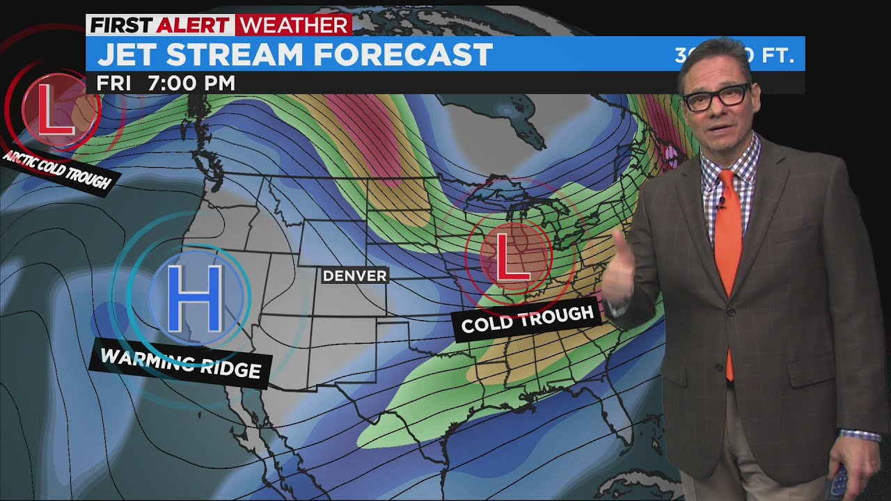
Warming Trend Before Next Arctic Blast
Video: Another arctic blast today

2025-2026 Winter: Record Snowfall & Arctic Outbreaks? #shorts
LAWTON, Okla. – Residents of Southwest Oklahoma are currently navigating an arctic chill, with a Cold Weather Advisory active through the late morning hours. However, a significant meteorological shift is on the horizon, promising a dramatic warming trend that will see temperatures climb steadily throughout the coming week, potentially reaching near 70 degrees Fahrenheit by Friday, according to a recent forecast from KSWO 7News.
Immediate Forecast: Arctic Air Persists Today
Today's weather in Lawton, Oklahoma, is characterized by the lingering effects of arctic air. Despite the ongoing Cold Weather Advisory, temperatures are projected to rise to approximately 30 degrees Fahrenheit this afternoon. The skies are expected to remain mostly sunny, offering some visual relief from the frigid conditions. As evening approaches, the region will see partly cloudy to mostly clear skies, with overnight lows anticipated to dip into the mid-10s. This continues the pattern of cold, clear nights that have defined the current arctic influence.
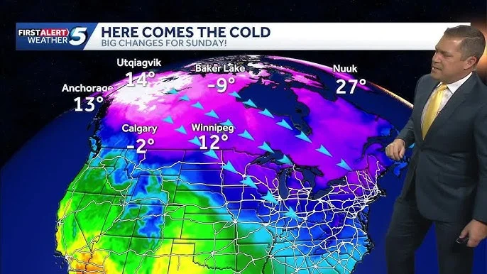
Sunday Marks the Start of a Drastic Warm-Up
The turning point in this week's weather pattern is Sunday, which is forecasted to usher in the beginning of a substantial warming trend. The day is expected to be both warmer and sunny, with temperatures reaching into the mid-50s. This represents a remarkable increase from the preceding days, offering a significant respite from the arctic conditions currently being experienced. The clear skies and milder air will provide a welcome change for residents across the region, setting the stage for an even more pleasant week ahead.
Mid-Week Weather: Mild Temperatures and Breezy Conditions
The warming trend is slated to continue and intensify from Monday through Thursday. During this period, temperatures are predicted to range from the mid-50s to 60 degrees Fahrenheit. The skies will largely remain favorable, with conditions alternating between partly cloudy and sunny. As the week progresses, particularly on Tuesday and Wednesday, residents can anticipate breezy conditions. A slight chance of a stray rain shower is also mentioned for Wednesday, though it does not appear to indicate a widespread precipitation event at this time. This consistent string of mild days will firmly establish the new, warmer weather pattern, a sharp contrast to the cold front that has dominated the area, as reported by KSWO 7News.
Friday: Peak Warmth Approaching Springtime Levels
By Friday, the region is expected to experience the warmest temperatures of the week, approaching conditions typically associated with early spring. The forecast indicates temperatures will be very mild, nearing 70 degrees Fahrenheit. Coupled with mostly sunny skies, Friday is poised to be an exceptionally pleasant day, providing a stark reminder of the rapid shifts in weather patterns often observed in this region. This dramatic increase from the current arctic blast to near-70-degree warmth within a single week underscores the dynamic nature of the local climate.
Outlook: From Advisory to Abundant Sunshine
In summary, Southwest Oklahoma is on the cusp of a significant weather transformation. After enduring a Cold Weather Advisory and bitter temperatures today, the region is preparing for a sustained period of warming. Sunday will initiate this trend with sunny skies and temperatures in the mid-50s. The upward climb in temperatures will continue through the week, with highs reaching into the 60s by mid-week and potentially touching 70 degrees by Friday, accompanied by generally clear to partly cloudy conditions and some breezy periods. This forecast, provided by KSWO 7News, suggests a rapid transition from winter's grip to much milder, almost spring-like, conditions.
Related Articles

Restaurants Scramble to Adapt as "Dry Dining" Trend Hits Alcohol Profits Hard
The "dry dining" trend, driven by Gen Z and millennials embracing sobriety for health and financial reasons, is forcing restaurants to innovate beyond high-margin alcohol sales, with mocktails and alternative social gatherings gaining traction.